(CNN)NASA has released the first snapshots of Earth taken with its new highly sensitive satellite which is designed to capture high-resolution images of the planet and help track the impacts of climate change.
NASA and the U.S. Geological Survey (USGS) have been collecting images of our planet using satellites since 1972.
The mission's most recent satellite, Landsat 9, launched in September this year, is equipped with two instruments that capture imagery and together provide experts with data about crop health, irrigation use, water quality, wildfire severity, deforestation, glacial retreat and, urban expansion.
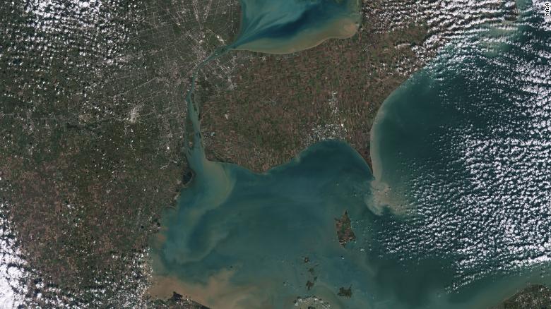
Sediments swirl in Lake Erie and Lake St. Clair in this Landsat 9 image of both Detroit, Michigan, and Windsor, Ontario, from Oct. 31, 2021. The Great Lakes serve as sources of freshwater, recreational activity, transport, and habitat for the upper-midwestern US, and water quality remains a high priority.
The Operational Land Imager 2 (OLI-2) detects visible, near-infrared and shortwave-infrared light in nine wavelengths, the combination of which can give experts more information about things beyond what the human eye can observe, like the health of vegetation, or the strength of a wildfire.
The satellite's other instrument, Thermal Infrared Sensor 2 (TIRS-2), observes thermal radiation in two wavelengths to measure Earth's surface temperatures and its changes, and can help experts track plant health.
"Landsat 9's first images capture critical observations about our changing planet and will advance this joint mission of NASA and the U.S. Geological Survey that provides critical data about Earth's landscapes and coastlines seen from space," NASA administrator Bill Nelson said in a statement.
Enter your email or view the Vault By CNN webpage to own a piece of CNN History with blockchain technology.

"This program has the proven power to not only improve lives but also save lives. NASA will continue to work with USGS to strengthen and improve accessibility to Landsat data so decision makers in America -- and around the world -- better understand the devastation of the climate crisis, manage agricultural practices, preserve precious resources and respond more effectively to natural disasters."
The first image collected by Landsat 9, on Oct. 31, 2021, shows remote coastal islands and inlets of the Kimberly region of Western Australia.
The first pictures show locations around the US, including Detroit in Michigan beside Lake St Clair, the intersection of cities and beaches on the changing Florida coastline, and observations from Navajo Country in Arizona "that will add to the wealth of data helping us monitor crop health and manage irrigation water," NASA said.
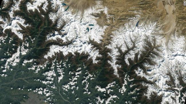
The snapshots also provide data about the changing landscapes of more of the world's crucial habitats, including the Himalayas in High Mountain Asia and the coastal islands and shorelines of northern Australia.
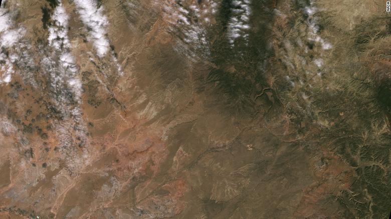
In the west of the US, in places like the Navajo Nation as seen in this Landsat 9 image, Landsat and other satellite data helps people monitor drought conditions and manage irrigation water.
Landsat 9 has several improvements on its predecessors: It transmits data with higher radiometric resolution back down to Earth, allowing it to detect more subtle differences over darker areas like water or dense forests.
Landsat 9 can differentiate some 16,000 shades of a given wavelength color, while Landsat 7, the satellite being replaced, detects only 256.
"First light is a big milestone for Landsat users -- it's the first chance to really see the kind of quality that Landsat 9 provides. And they look fantastic," said Jeff Masek NASA's Landsat 9 project scientist at Goddard Space Flight Center.
Landsat 8 will remain in orbit, and together, the two satellites will report on changes to Earth every eight days.
[Top photo: The city of Kathmandu, Nepal, seen at the bottom left of this Landsat 9 image, lies in a valley south of the Himalayan Mountains between Nepal and China. Glaciers, and the lakes formed by glacial meltwater, are visible in the top middle of this image.]