Articles Menu

Editor: Note the date of this piece. So there were warnings.
May 10, 2012
The Fraser River is at risk of much more frequent and devastating floods because of the rapid pace of logging in the B.C. Interior to salvage vast stands of beetle-killed timber, according to a UBC researcher.
“The public needs to know how much they’re at risk so they are prepared,” he said. “People’s lives are at stake. Economic disruption is at stake.”
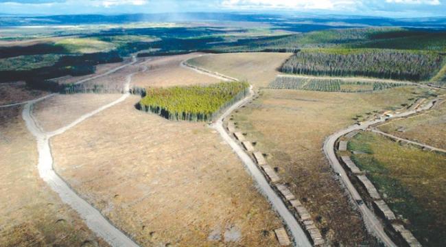
Alila looked at small tributary drainages in the Interior and found much faster rates of runoff in areas that have been heavily logged in response to the mountain pine beetle epidemic.
“The 100-year flood may come once in 20 years,” Alila said. “It could easily become five times as frequent.”
He cannot say with certainty that his findings from smaller upcountry tributaries translate directly to more risk of the mainstem Fraser flooding in the Lower Mainland.
But much of the runoff that ends up going through the lower Fraser Valley originates in snow melting in the upper Fraser, Nechako or Cariboo – areas of the watershed heavily hit by the beetle where logging crews have been authorized to cut at unsustainably high levels so wood isn’t wasted.
Alila said the upper 60 per cent of the Fraser basin is also particularly sensitive to rapid runoff from logging because much of the region has relatively flat, subdued topography.
The snowpack melts faster in logged areas because there are fewer trees to shade and slow the melt, he said. Less water is absorbed by tree roots or evaporates due to snow being held aloft in branches.
Snow in more mountainous areas tends to melt at different rates because of the differing elevations and aspects, but on flatter terrain the melt is more synchronized and flooding can be much worse.
The Nechako and upper Fraser basins are also the ones where snowpack levels this spring are 50 per cent above normal, contributing to an elevated risk of flooding throughout the watershed, according to the River Forecast Centre.
Alila said more intense, heavy runoff in the Interior due to salvage logging will also result in more scouring of channels throughout the watershed, increasing the amount of silt and sediment ultimately deposited in the lower Fraser.
More silt effectively raises the riverbed in the Lower Mainland and reduces the Fraser’s capacity before dikes are overtopped.
Alila said the province has known about the threat since at least 2006, when a previous study for the Forest Practices Board first raised the potential for rapid runoff.
He argues the province should reduce salvage logging or do it more selectively, and ensure logged areas are rapidly replanted to quickly provide shade.
Dave Maloney, a forest water management officer for the province, said Alila’s findings were reviewed by the forests ministry.
He did not disagree with the research – noting hydrologists have previously said runoff in beetle-infested areas is a concern – but added Alila focused on Baker Creek, a particularly flat watershed in the Quesnel area that may have amplified his results.
Maloney said forest companies are responsible for weighing the risks of flooding from their operations and taking steps to mitigate it.
“The chief forester came out and provided guidance to the licensees regarding hydrologic risk and where they should focus their harvesting in areas with high densities of pine.”
Delta Mayor Lois Jackson said Lower Mainland mayors are continuing to press the federal government for support to dredge sections of the river to reduce the risk of a flood.
“We are very actively pursuing this,” she said, adding a rapid melt from the Interior is a concern.
“There’s no root systems to hold the water so it’s going to just roar down the slope. Hopefully we’re going to get more tree planting going on out there.”
The build-up of river silt is a serious problem, Jackson added, noting side channels of the Fraser near Ladner and Richmond are becoming less usable as boat harbours.
More than 300,000 people live on the lower Fraser’s floodplain, according to the Fraser Basin Council, and a major flood would cause billions of dollars in damage along with possible loss of lives and injuries.
It estimates there’s a one-in-three chance that a flood as big as the two largest on record – in 1894 and 1948 – will strike within the next 50 years.
“A major flood today would result in severe social, economic and environmental impacts,” the council says.
[Top photo: UBC associate professor Younes Alila - Salvage logging in the Baker Creek watershed west of Quesnel, .]