Articles Menu
Mar. 31, 2024
Water in the Fraser River where it meets with the Nechako — itself not much more than a trickle in some spots — is at an all-time low, according to the River Forecast Centre.
It's a dramatic reflection of drought in Prince George, and of the dry conditions that have plagued much of the province since the summer of 2023 in what B.C.'s emergency minister has called "a sleeping giant of a natural disaster."
The riverbed has also created an impromptu park for adults, kids and pets to explore the sand and rock normally buried under rushing water.
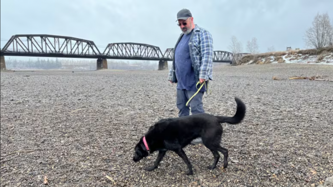
"This is sad and great at the same time," said Prince George resident George Soares, as he walked along Goat Island, a small hill typically surrounded by waters from the Fraser River which, right now, is completely dry land.
"I've never seen it this low before."

"It's terrifying to see the river almost completely gone," John Grove, another resident, said.
"To be able to walk all around is just insane to me.... I would love to see more of a river here."
The area they are walking is near the CN Rail Bridge, built by the Grand Trunk Pacific Railway in 1914, which still has the ability to open to allow shipping vessels and sternwheelers to pass through, although there hasn't been a need in decades.
It's also on the land of the Lheidli T'enneh, a First Nation whose name means "people of the confluence" — a reflection of the importance the joining of the Fraser and Nechako Rivers have had to the nation and the region for centuries.

Spring is when the city typically braces for flooding, as a melting snowpack sends water levels surging along the rivers — but this year, that is not going to be a concern for residents, says hydrologist Jonathan Boyd with the River Forecast Centre.
"The likelihood of any flooding this year [in Prince George] is very low if not just almost zero because of how low [the water level] is," he told CBC News.
With snowpack levels 44 per cent below normal in the Upper Fraser River Basin, which includes Prince George, Boyd says he fears drought could worsen this year.
Currently, the basin has been experiencing drought level four on a five-point scale, where ecosystem or socio-economic impacts are likely to occur.
In an email to CBC News, mining giant Rio Tinto — which manages the Nechako watershed through reservoir operations, and diverts water to power its aluminum smelter — confirmed the reservoir is at an all-time low, operating at about 24 per cent of capacity.
"[We] are actively addressing the ongoing impacts of drought on our operations by proactive generation reduction and working with B.C. Hydro to ensure residents and businesses in the region receive the power they need when they need," the statement reads.
The 233-kilometre-long Nechako Reservoir typically contributes about half of the annual discharge in the Nechako River in Prince George, says Stephen Déry, environmental science professor at University of Northern B.C., and Rio Tinto senior industrial research chair on climate change and water security.

Boyd, with the River Forecast Centre, says reservoirs play an important role in responding to natural disasters like flood and drought.
"If we ever were to end up in a situation where we had very high snow and a rapid melt, the reservoir can actually hold water back and prevent catastrophic flooding," he said, adding that during prolonged dry spells, additional water is typically released from reservoirs into the rivers.

Déry says "with the reservoir being so low, we cannot foresee water being essentially released into [the river during spring]."
He blames climate change for the unprecedented drought conditions.
"I think it's an emerging pattern associated with climate change and a combination of factors," he said.
"We had El Niño, that was quite prominent. The sea surface temperature in the tropical Pacific Ocean were above average for the last two years,... which have led to very warm temperatures and the ongoing drought."
He adds that El Niño is now on its way out, and "near-neutral El Niño conditions" can be expected.
"We might actually see average precipitation this summer, perhaps above average coming into the fall and winter."
With files from Andrew Kurjata and Betsy Trumpener
[Top photo: George Soares says being able to walk his dog across what is normally a riverbed is 'sad and great at the same time,' providing new areas to explore while prompting concerns about the province's ongoing drought. (Andrew Kurjata/CBC)]