Articles Menu
Dec.13, 2022
THERE’S BEEN A LOT OF WRITING over the past year about the “Big Lie” in American politics: A deliberate, gross distortion of the truth, repeated over and over, even in the face of evidence that what’s being claimed is false.
This isn’t just a sickness affecting American politics. Month after month, around the globe, scientists uncover more of the truth about how badly humanity has overshot Earth’s ecological limits. Perversely, the scientists’ dire warnings simply cause governments, corporations and their political proxies to respond with measures that protect the status quo. Rather than addressing the issues head-on and making plans to address the overshot in a meaningful way, these entities resort to greenwashing, denial and deliberate, gross distortions of the truth.
The British Columbia government has its own version of a Big Lie, which it uses to manufacture continued public consent for the immense transformation of 220,000 square-kilometres of BC’s publicly owned primary forests into clearcuts, permanent logging roads and managed, short-rotation monoculture plantations.
BC’s deliberate, gross distortion of the truth has two parts: First, that this transformation is being conducted under strict, science-based regulations that ensure “sustainability.” And second, that the liquidation of natural forests is being carefully monitored using powerful information technology to ensure we don’t exceed natural limits.
Both of these claims can readily be shown to be false, yet government and industry make them so often that almost everyone believes them.
Real progress at turning away from the endless, destructive exploitation of nature in our province won’t be possible until the BC government acknowledges the deception behind its claims of strict regulatory control and creates an accurate inventory of what remains of nature in this province—and a plan for how to restore it where it is most damaged.
If new Premier David Eby’s commitment to sustain BC’s biodiversity by doubling the amount of protected area by 2030 is to be successful, it’s essential that his initiative doesn’t become just another exercise in protecting more rock and ice and adding more territory to BC’s Big Lie.

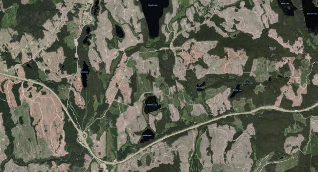
This satellite photo of logging west of Kelowna covers an area of 63 square kilometres. The 220,000 square kilometres of primary forest in BC that is being converted to clearcuts, logging roads and plantations is 3,500 times greater than the area shown here (click image to enlarge). For context, the entire state of Washington covers 184,827 square kilometres.
Does BC have strict, science-based regulations that ensure the “environmental sustainability” of converting primary forests to managed plantations?
The short answer to that question is “No.” Converting primary forests, most of which are old, to short-rotation industrial plantations in which trees will never be allowed to grow old, profoundly changes the nature of a forest. Just one example of that change: The species of animals that need old primary forest—like Marbled Murrelets, Northern Goshawks and Mountain Caribou—won’t survive for long in a landscape covered by clearcuts, logging roads and managed plantations. It would take hundreds of years for an old forest ecology to re-emerge, but that’s not in the government’s plan. So how could the conversion ever be considered “environmentally sustainable”?
It follows, then, that when anyone claims logging in BC occurs according to strict regulations that ensure environmental sustainability, the only part of that claim that might be true is the “strict regulations” part. So let’s examine that.
After the BBC recently caught the British energy corporation Drax in the act of logging primary forest southeast of Prince George and turning it into fuel pellets, one of the defences Drax CEO Will Gardiner offered was this: “Areas identified by the [BC] Government for harvest are carefully selected by them using an exhaustive list of environmental criteria that includes but is not limited to; old growth management; landscape and site level biodiversity; age class distribution (old growth); riparian management; watershed management; wildlife management; visual quality; species at risk; rare and sensitive ecosystems; cultural heritage resources; soil quality; species diversity; site productivity; as well as social and economic considerations.”
Gardiner was repeating the first part of the lie: Logging companies in BC labour under a great weight of stringent science-based regulations imposed by the government that are designed to ensure environmental sustainability.
A more succinct expression of this part of the lie was recently offered by then BC Forests Minister Katrine Conroy, who explained to a Business in Vancouver reporter why other countries—like Japan—prefer to buy wood products from BC: “They recognize that we have some of the most stringent regulations for environmental sustainability when it comes to how we take care of our forests, as well as how we harvest them.”
But the claim that BC has “stringent regulations for environmental sustainability” is not actually supported by forest legislation. Instead, all of BC’s legislated, science-based “stringent regulations” aimed at protecting non-timber values can only be enforced to the extent that they do not “unduly reduce the supply of timber from British Columbia’s forests”.
That constraint on regulation, by its use seven times in the Forest Planning and Practices Regulation, legally limits the extent to which wildlife, soils, fish, riparian areas, sensitive watersheds and biodiversity (at both the landscape and stand levels) can be protected when an area is logged.
To what degree are conservation objectives limited by the “unduly” clauses? Pretty darn close to 100 percent.
.jpg.71bf77f563ef024d6eb4d59237efce79.jpg)
Logged and burned primary forest in the Klanawa Valley (Photo by TJ Watt)
That detail is not spelled out in the Forest Planning and Practices Regulation itself. But a Ministry of Forests’ document written by staff of the Forest and Range Evaluation Program in 2003, just before the Regulation was enacted, stated that the impacts of conservation objectives on timber supply were to be capped at no more than 6 percent—province-wide (1).
The reason for the “unduly” clauses in the Forest Planning and Practices Regulation was also made clear in the document: “The intent of this language is to ensure that conservation of non-timber values is undertaken in balance with economic benefits”.
That lop-sided, politically determined “balance”—94 points for logging and 6 for conservation—makes it clear that imposing “stringent regulations” was never the purpose of the legislation.
The purpose was to create laws that appear to impose stringent regulations without actually imposing stringent regulations.
The Forest Planning and Practices Regulation and its hidden cap on timber supply impact have allowed 20 more years of nearly unfettered destruction of primary forests, while at the same time providing excuse-makers in government and industry with credible “proof” that it’s all under control.

Can you spot the protection of conservation values in this clearcut east of Prince George? (Photo: Sean O’Rourke/Conservation North)
The office that’s supposed to enforce those “stringent regulations” is the Natural Resources Compliance and Enforcement branch (C&E). But its record of protecting BC’s forested ecosystems suggests that it knows it’s not supposed to do anything that might impact timber supply. Over the last 11 years, C&E has failed to get even a single administrative penalty, administrative sanction or court conviction against any company or individual under the Forest and Range Practices Act, the Forest Act, the Forest Stand Management Fund Act, or the Forest Practices Code of British Columbia Act, according to its public record of such cases.
You might think that’s because no one in the logging industry has done anything wrong in the last decade.
But I know of one slam-dunk case in which old primary forest on Quadra Island was logged in contravention of the tenure-holder’s commitment to retain old forest—and C&E declined to investigate due to budgetary and staff constraints.
According to the BC government directory, C&E currently employs 8 people as “investigators” of infractions of forest-related laws. To cover the entire 22-million-hectare timber harvesting land base—the area in which logging is occurring in BC—each investigator would be responsible for an area about the size of Vancouver Island.
By putting a 6 percent cap on the impact that conservation measures can have on timber supply, the forests ministry long ago signalled to its managers, employees and the logging industry that it wasn’t watching to see if science-based objectives were being met—or any other nicety of “environmental sustainability” either.
By the way, this idea of arbitrarily limiting the impact of conservation measures on timber supply wasn’t invented by Gordon Campbell’s Liberals. Under the 1990s NDP government that preceded the Liberals, provisions for protecting biodiversity were subject to a 4 to 4.3 percent cap on timber supply impact (2). Different government, same message, same reason: To ensure that conservation of non-timber values is undertaken in “balance” with economic benefits.
You might be wondering: “What should the balance between logging and conservation have been?” Let me answer that question and that will lead us to the second part of BC’s Big Lie.

Logging of primary forest near Prince George (Photo: Sean O’Rourke/Conservation North)
If BC did have stringent, science-based regulation of logging, what should the balance between logging and conservation be?
The basic consensus of provincial forest scientists back in the 1990s and early 2000s was that logging would not threaten biodiversity unduly if it mimicked natural disturbances. After all, nature itself eventually turns old forest into young forest: by blowing it down, burning it, infesting it with insects or infecting it with disease. If logging mirrored the rate at which old forest is naturally turned back into young forest, the scientists reasoned, then logging would present only a low risk of biodiversity loss.
But it has turned out that the natural rate at which old forest is turned into young forest is much slower, and the areas impacted are smaller in size, than had been understood in the 1990s when land use planning for BC’s publicly-owned forests began.
A 2003 study (3) by forest ecologist Dr. Karen Price and forester Dave Daust found that forests on Haida Gwaii and on the central mainland coast were disturbed far less frequently—and those disturbances involved much smaller areas—than forest scientists had previously understood.
That finding meant that, in their natural state, BC forests would have contained a much higher percentage of old forest than had previously been estimated. If the rate of logging was going to mimic nature, then in order to protect biodiversity and other ecological values, a much higher percentage of old forest than government had planned to leave would need to be left for nature.
For example, where I live on Quadra Island, the return interval for stand-replacing natural disturbances was estimated at 200 years in 2001 (Biodiversity Guidebook). The minimum old forest retention target on Quadra Island, based on that return interval, was 9 percent. But the 2020 Interim Assessment Protocol for Forest Biodiversity in British Columbia, which has built on Price’s, Daust’s and other forest scientists’ findings, now estimates the stand-replacing disturbance return interval on Quadra Island and surrounding area to be 700 years. It’s now estimated that old forest (greater than 250 years old) would have covered about 70 percent of the forested area of the island (4).
According to other work (5) done by Price, Daust and forest ecologist Dr Rachel Holt, keeping the risk of biodiversity loss to “low” would mean maintaining at least 70 percent of that area of old forest. So at least 49 percent (70 percent of 70 percent) of the forested area of Quadra Island would need to be old forest to keep the risk of biodiversity loss to “low”—far above the 9 percent used as a guide to manage old forest there since 2001.
On Quadra Island, the imposed “balance” of 94 to 6 in favour of economic use over conservation of old forest should have been more like 50-50. But under the current management regime, the area of old forest has been allowed to fall to just under 4 percent of the original forested area on Quadra Island (6).
The impact of all those years of logging old forest far past the limits of ecological sustainability in BC has left us with a collapse in biodiversity and a critical need to draw lines around the remaining old forest. The most advanced forest scientists tell us we urgently need to implement our new science-based understanding of how much old forest is needed to protect biodiversity. We would do that by identifying suitable old forest, providing it with legal protection, and if that’s not enough, then recruiting the balance needed from mature second-growth forests in the timber harvesting land base.
And that brings us to the second part of BC’s Big Lie: That the BC government has a reliable inventory of the provincial forest, and, in particular, the extent of old forest that remains, and where it is.

Removal of primary forest in the Inland Temperate Rainforest (Photo: Mary Booth/Conservation North)
Is the liquidation of primary forests in BC being carefully monitored?
First, let’s consider why having a reliable inventory of old forest is essential.
A New Future for Old Forests, the report of the Strategic Review of How British Columbia Manages for Old Forests Within its Ancient Ecosystems, appeared in September 2020. Since then the Ministry of Forests has struggled to implement temporary logging deferrals in some old-growth forests. One of the criticisms of the deferral process has been that logging has continued in old forests despite the deferrals. But there is an even more fundamental problem with the process: The Ministry of Forests doesn’t have a good understanding of how much old forest remains, or where it’s located.
Yet an accurate assessment of each of these will be critical to the success of the current old-growth logging deferral process and Premier Eby’s promised doubling of protected areas by 2030. If an area is deferred because the ministry believes it contains old forest but it doesn’t, and another area that does contain old forest isn’t deferred, the process could end up being a pointless exercise in drawing meaningless lines on maps.
To identify at-risk old forest, the deferral process has relied entirely on a Ministry of Forests’ inventory called the Vegetation Resource Inventory (VRI) that estimates, among other things, the age, site index and dominant tree species growing in almost every stand of BC’s publicly owned forests. The database is used in decisions about where to log and how much can be logged and it is held up by the Ministry of Forests as just one of the many powerful, science-based tools it has for managing the “sustainable” liquidation of old forest.
But is VRI accurate? No. In terms of locating old forest, throwing a dart at a map would be just as accurate.
Over the past four years, the Discovery Islands Forest Conservation Project has been mapping the remaining old forest on Quadra Island and other islands in the Discovery Islands area. Like the Ministry of Forests, the project uses analysis of satellite photography. But unlike VRI, the project complements satellite image analysis with local knowledge, extensive drone videography and, finally, on-the-ground confirmation that old forest is indeed present.
There is very little similarity between the mapping of old forest being used by the Technical Advisory Panel (TAP) to identify old forest and the Discovery Islands project’s mapping of old forest. In general, VRI puts old forest where there isn’t any and misses the vast majority of actual old forest on Quadra Island. Of the 171 small fragments of old forest the project has mapped so far, only 19 of those overlap with areas in TAP’s Priority Deferral Map. Since the total area of old forest on Quadra Island is down to around 4 percent of the area of the original forest (6), old-forest-dependent biodiversity could hardly be at higher risk. All the remaining old forest needs to be deferred.
Yet logging of old forest is still occurring on Quadra Island and the ministry’s inventory doesn’t even know it’s there.
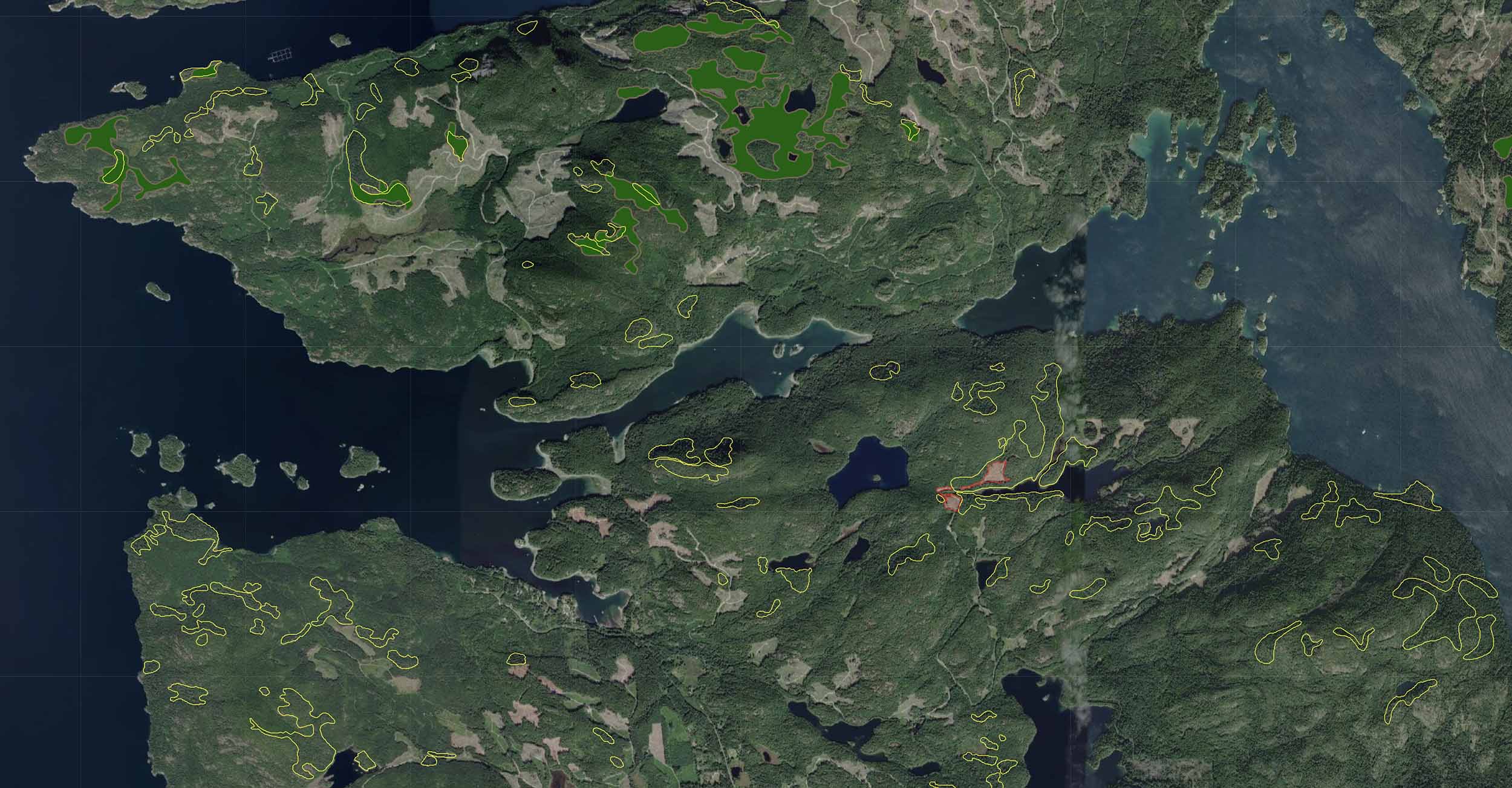
Priority deferral areas (solid green) on Quadra Island have little overlap with actual areas of old forest (outlined in yellow) found and mapped by the Discovery Islands Forest Conservation Project (click image to enlarge).
One particular failure by VRI to identify old forest seems emblematic of its inaccuracy: The TAP Priority Deferral Map, using VRI, shows there are only two small remnants of “Ancient Forest” remaining on the Discovery Islands. TAP says that this is forest that has been “identified as over 400 years old”.
The Discovery Islands Forest Conservation Project visited one of these two areas of “Ancient Forest”, a 5.7-hectare patch at Rosen Lake on Read Island. Unfortunately, this “Ancient Forest” had been logged sometime early in the 20th century and is now covered with second growth. On our visit we observed two or three large, old Douglas firs that undoubtedly were over 400 years old, rejected by the first loggers.
Yet VRI showed the “projected age” of the forest as “833 years”. By the way, this area was in Read Island Provincial Park and is an Old Growth Management Area. So there was no need for it to be mapped as a priority deferral area.
Perhaps even worse, though, a portion of the road into Rosen Lake was also given priority deferral. Just the road mind you, not the forest on either side of the road.

Above: The forest at Rosen Lake, one of just two areas of “Ancient Forest” on the Discovery Islands, according to the Vegetation Resource Inventory. The inventory says it is 833 years old, but it had been logged in an era when loggers used spring boards, axes and crosscut saws. (Photo: David Broadland)
On the other hand, the Discovery Islands Forest Conservation Project has identified several areas of “Ancient Forest” on Quadra Island that aren’t acknowledged in the VIR database.
I have no reason to believe that VIR’s inaccuracy in predicting where old forest is on the Discovery Islands is any different from the province as a whole.
To be fair, TAP warned that such errors were going to occur and that the Vegetation Resource Inventory would be the source of the inaccuracy. It’s not the deferral process that we need to be wary of. It’s the quality of the tools the Ministry of Forests has created to conduct its program of old forest liquidation that are the problem. They certainly don’t work for identifying old forest, but the problem is much larger than that.
All timber supply reviews and allowable annual cut determinations in BC over the past 20 years have relied on the Vegetation Resource Inventory to predict the existing volumes of wood remaining in unmanaged forests. Yet the inventory is hopelessly inaccurate. I’ve written previously about the failure of the ministry’s growth and yield models to accurately predict growth and yield in managed plantations, its failure to incorporate uncertainty in its calculations, and its refusal to be guided by the precautionary principle. The ministry’s tools and operational choices seem ideally suited for producing self-delusion: The ministry has an unshakeable belief that it knows what it is doing and what the outcomes will be. But in 2021, a year of record market demand and high prices for BC wood products, what publicly owned forest could be found to log only amounted to 62 percent of what the ministry timber-supply experts had long predicted would be available.
Is it a Big Lie—or just a Big Delusion?
For BC’s “Big Lie” to meet the definition of a lie, the tellers of the lie must know that what they are saying is not true but say it anyway. There needs to be an intention to mislead.
But did former Forests Minister Conroy know about the “unduly” clauses in BC’s forest legislation? Did the minister know about the 6 percent cap on the impact of conservation measures on timber supply? Did she know about the under-resourced Compliance and Enforcement branch and the failures of her ministry’s vaunted information technology? If she didn’t, then whenever she boasted about the “environmental sustainability” of BC’s logging industry, she wasn’t really telling a lie.
She was merely suffering from an unshakable belief in something that’s untrue—a delusion.
We can only hope that new Premier David Eby and new Forests Minister Bruce Ralston are neither liars nor prone to delusion. But only time will tell.
David Broadland started working for the Discovery Islands Forest Conservation Project in 2018 and thinks other people would enjoy the experience of discovering old forest that—according to the Ministry of Forests—doesn’t exist.
[Top photo: This satellite photo of logging west of Kelowna covers an area of 63 square kilometres. The 220,000 square kilometres of primary forest in BC that is being converted to clearcuts, logging roads and plantations is 3,500 times greater than the area shown here (click image to enlarge). For context, the entire state of Washington covers 184,827 square kilometres.]