Articles Menu

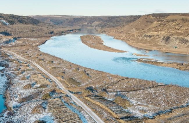
A series of new aerial photographs show the massive scale of early construction work on the $8.8-billion Site C dam.
Victoria-based photographer Garth Lenz flew over what will be the dam site in June 2014 and returned Sunday to re-shoot the area. Lenz said even though he had flown over the site before, he was not prepared for what he saw.
“I was surprised at how big an area was being destroyed,” said Lenz, who photographed just a few kilometres of a flood zone that stretches more than 80 kilometres upriver.
The Ministry of Forests, Lands and Natural Resource Operations issued BC Hydro its first set of construction permits in July.
Recent decisions in Federal and B.C. Supreme Court rejected attempts by the West Moberly and Prophet River First Nations to halt the project.
“I do remain hopeful. I’ve got young kids so you don’t have the luxury of being pessimistic,” Lenz said.
Lenz has shot construction projects around the world and his other work can be found at garthlenz.com.
Lenz’s original 2014 photograph was taken south of the point where the Moberly River reaches the Peace River about seven kilometres southwest of Fort St. John. The dam will cross the Peace just south the Moberly.
“Those areas that are further up are even more beautiful,” Lenz said, describing a rich, green valley.
Piles of cut trees line the south bank of the Peace River on Sunday. The bluffs above the bank are covered in tidy piles of downed trees. The dam, generating station and associated structures are slated for part of the cleared area.
[End of article]